Most Christian bibles and travel maps espouse the widely accepted view that Moses and the Israelites crossed the Red Sea at the Gulf of Suez. Furthermore they nearly all place Mount Sinai on what is known (for apparently the wrong reasons!) as the Sinai Peninsula. This page will show that both of these widely held views are erroneous (would you expect anything less?).
The Israelites Crossed the Red Sea at the Gulf of Aqaba, Not at the Gulf of Suez.
The Exodus of the Israelites began at daylight on the day of the passover. We know this because Exodus says:
31 At once he called Moses and Aaron by night and said: Get up, get out from the midst of my people, both you and the [other] sons of Israel, and go, serve , just as you have stated.
32 Take both your flocks and your herds, just as you have stated, and go. Also, you must bless me besides.
33 And the Egyptians began to urge the people in order to send them away quickly out of the land, because, they said, we are all as good as dead!
34 Consequently the people carried their flour dough before it was leavened, with their kneading troughs wrapped up in their mantles upon their shoulder.
35 And the sons of Israel did according to the word of Moses in that they went asking from the Egyptians articles of silver and
articles of gold and mantles.
36 And gave the people favor in the eyes of the Egyptians, so that these granted them what was asked, and they stripped the Egyptians.
37 And the sons of Israel proceeded to depart from Rameses for Succoth, to the number of six hundred thousand able-bodied men on foot, besides little ones.
38 And a vast mixed company also went up with them, as well as flocks and herds, a very numerous stock of animals.
39 And they began to bake the flour dough that they had brought out from Egypt into round cakes, unfermented cakes, because it had not leavened, for they had been driven out of Egypt and had not been able to linger and too they had not prepared any provisions for themselves (Exodus 12).
The year was in fact 1513 - see U9. The trip from Rameses to Succoth lasted from 1513Nisan15 to 1513Nisan21. This being the entire length of the festival of unfermented cakes, which festival commemorates this flight. They set up camp at Succoth. This was the end of the first stage of their flight. Whilst setting up camp the Israelites would have had time to bake fermented bread. For the chronology of the Exodus see U356.
The Sinai Peninsular was Egyptian controlled territory in the day of the Exodus, as it is today! But it was not actually in the land of Egypt itself.
17 And it came about at the time of Pharaoh’s sending the people away that God did not lead them by the way of the land of the Philistines just because it was near,
for God said: It might be the people will feel regret when they see war and will certainly return to Egypt.
18 Hence God made the people go round about by the way of the wilderness of the Red Sea (Exodus 13).
The land of the Philistines was to the north and east of Rameses. So God must have sent them South and East or Southeast in fact. In verse 18 we are told that 'God made the people go round about by the way of the wilderness of the Red Sea'.
This great photo shows the Gulf of Suez to the left and the Gulf of Aqaba to the right. There is a large mountainous area stretching across the southern half of the Sinai Peninsula, with desert plains to the north and a coastal plain along its western edge. It would not have been possible to take 2-3million people including women and children mountain hiking for 2 weeks, so they must have travelled along either the desert plains to the north or the coastal plain along the western side of the mountains. Some writers have identified the whole of the peninsula as 'The Wilderness of the Red Sea' but, as we shall see, this wilderness is most likely to be the coastal plain shown above running between the Gulf of Suez and the mountainous region of the peninsular. Furthermore the Northern route would have exposed the sons of Israel to attack by the Philistines, which God was deliberately avoiding. So they must have travelled down the coastal plain on the eastern border of the Gulf of Suez, and this then was the wilderness of the Red Sea.
We now come to the following accounts in Exodus and Numbers:
1 now spoke to Moses, saying:
2
Speak to the sons of Israel, that they should turn back and encamp near Pihahiroth between Migdol and the sea near Baal-zephon. Opposite it [Baal-zephon] you are to encamp by the sea.
3 Then Pharaoh will certainly say respecting the sons of Israel, ‘They are wandering in confusion in the land. The wilderness has closed in upon them.’
4 So I shall indeed let Pharaoh’s heart become obstinate, and he will certainly chase after them and I shall get glory for myself by means of Pharaoh and all his military forces; and the Egyptians will certainly know that I am .
Accordingly they did just that. (Exodus 14)
9 And the Egyptians went chasing after them, and all the chariot horses of Pharaoh and his cavalrymen and his military forces were overtaking them while camping by the sea, by Pihahiroth opposite of Baal-zephon. (Exodus 14)
7 Next they pulled away from Etham and turned back toward Pihahiroth, which is upon the faces (ynp) of Baal-zephon, and they went camping near Migdol. (Numbers 33)
The meaning of the Hebrew word Pihahiroth is broken down as follows:
'Pi' means 'mouth of' or can mean 'to flow out'.
'ha' means 'the'.
'hiroth' the meaning is not clear. It possibly comes from the Akkadian word 'hir-i-tu' meaning 'canal' or 'channel', it doesn't appear in any other bible accounts (apart from those of the red sea crossing). Therefore the whole word means 'mouth of the channel' or the channel estuary or the gulf estuary. Plainly this is the estuary of the gulf of Aqaba. The phrase 'upon the faces of' appears in Genesis 1:2, where God's spirit moves upon the faces of the waters.
The word 'Migdol' means 'tower/fortress' or even 'watchtower'
The word Baal-zephon is thought to have been the name of a Canaanite God who watches over mariners. According to Dr. Kyle McCarter of Johns Hopkins University and Dr. James Hoffmeier of Wheaton College, Baal-zephon is believed to be a coastal mountain. Ancients did used to view the mountains as gods, so it is quite possible that a mountain next to the sea would be thought of as a God who watches over seafarers. If we take into account these meanings, with what we have covered so far, we can begin to narrow down the location of where the crossing took place.
We are told that the Israelites encamped by the sea...
'near' (Exodus 14:2) - Pihahiroth, which was 'upon the faces of' Baal-zephon
'near' and 'opposite' (Exodus 14:2) and also 'to the east of' (Numbers 33:7) - Baal-zephon,
and 'between Migdol and the Sea' (Exodus 14:2) but also 'near' (Numbers 33:7) -
Migdol.
So, Migdol means watchtower/fortress, and it is believed to be the ancient site of a military watchtower. The Egyptians, as with all ancient armies, would place their watchtowers upon hills overlooking strategic terrain (a lookout at the mouth of the Gulf of Aqaba would have been a very strategic one, being able to monitor the passage of all ships entering/exiting the gulf). So it is very likely Migdol is, or was on a hill at the mouth of the gulf.
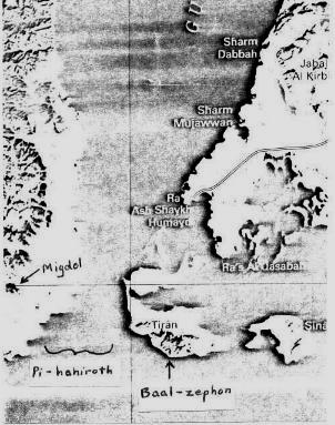
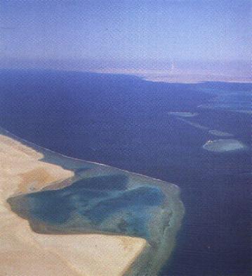
If it is, then the Israelites camped between a hill and the sea, and also near it, indicating it was nearby. If Baal-zephon is a mountain, then they were also in view of this mountain but also opposite it, so it must of been on the opposite shore or on an island in the gulf. We now know that Pihahiroth means 'the mouth of canal/channel(?)'. The picture below gives us a rough idea of the geographical features of the area at the mouth of the Gulf of Aqaba where the Israelites camped before the crossing:
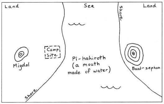
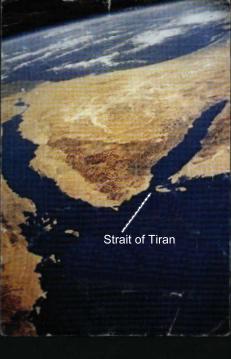
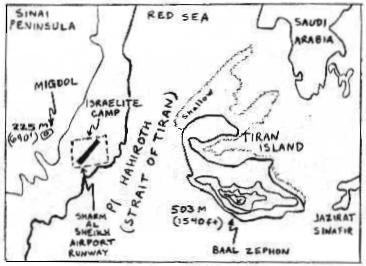
The next pictures elaborate further, showing Tiran Island, which along with the coast of the Sinai Peninsula forms the Strait of Tiran, which is basically the narrow mouth of the Gulf of Aqaba, where it opens into the main body of the Red Sea. The center and right hand pictures show that Tiran Island has a 1540ft mountain upon it, a prime candidate for Baal-zephon. There does not appear to be any other high mountain on the Arabian coast, the central satellite image below shows mainly flat terrain except for the mountain on Tiran Island. The mouth of the Gulf is also said to be 'upon the faces of' of this mountain. This is gives the impression that the water surrounded the mountain (being upon every face),
so the mountain was on an island. The Gulf of Suez does not have such a mountain on such an island. One can imagine Tiran Island as a God overseeing the shipping entering and leaving the gulf of Aqaba. It is the sort of place where one might expect to find a lighthouse.
The right hand picture below shows a 690ft hill, 3.4 miles inland on the Sinai Peninsula. It overlooks the strait and is an obvious place for a lookout tower. This has to be Migdol. The right hand picture indicates how the Israelite's camp was between the hill (Migdol) and the island mountain (Baal-zephon),
and near the mouth of the Gulf of Aqaba (Pihahiroth).
Apparently, the Sharm-al-sheik airport is now situated at this site. So what was a makeshift departure lounge for the Israelites from Egyptian control is now really a departure lounge for Egyptians themselves!
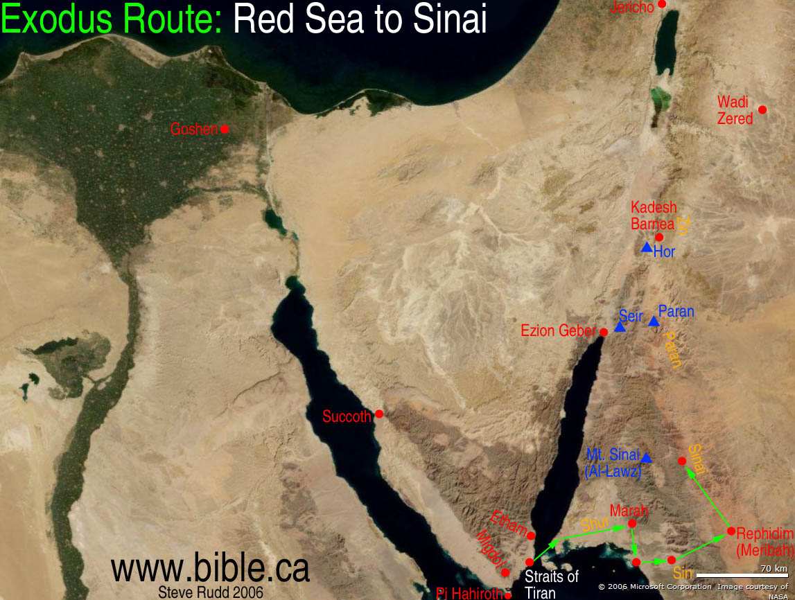
To get to the crossing point at Sharm Al Sheik Airport, the Israelites would have taken the coastal plains route, the flat strip of terrain between the western border of the mountainous region and the east coast of the gulf of Suez in order to avoid the philistine harassment. But the following scripture also confirms this route:
18 Hence God made the people turn around about by the way of the desert of the Red Sea.
(Exodus 13)
The Red Sea desert is the obviously a desert that is bounded by the Red Sea.
This scripture says that God turned the people so to travel the way of this desert. So they obviously turned south and traveled along the wide coastal plain, next to the Red Sea. The route along the northern edge of the mountains of the peninsular was a 'desert of the mountains' not a desert of the sea.
Next we read:
1 now spoke to Moses, saying:
2
"Speak to the sons of Israel, that they should turn back and encamp near Pihahiroth between Migdol and the sea near Baal-zephon. Opposite it [Baal-zephon] you are to encamp by the sea.
3 Then Pharaoh will certainly say respecting the sons of Israel, ‘They are wandering in confusion in the land. The wilderness has closed in upon them.’
4 So I shall indeed let Pharaoh’s heart become obstinate, and he will certainly chase after them and I shall get glory for myself by means of Pharaoh and all his military forces; and the Egyptians will certainly know that I am ."
Accordingly they did just that. (Exodus 14)
So the Israelites must have at some point already passed Pihahiroth, Migdol and Baal-Zephon, as they are told to 'turn back' and camp by these places. So they must have started to travel northwards up the western coast of the gulf of Aqaba after passing Migdol, before they turned around.
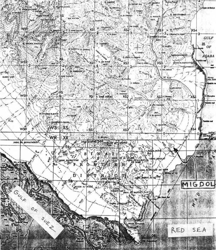
The image above left shows the southern point of the Sinai Peninsula. We can clearly see the flat plains along the coast, and how they curve around the tip of the peninsula and start to head northeast. If you look to the left of where it says 'Gulf Of Aqaba' on the map, you can see the flat plains come to a dead end, as the mountains shut off the coastal route. This is also very clear on the left hand side of the map to the right. So it is likely the Israelites neared this dead end and then God told them to turn back and encamp at the Pihahiroth/Migdol/Baal-zephon site. If Migdol was an Egyptian watchtower then the report would have come from there, back to Pharaoh,
who was already pursuing the Israelites, notifying him that the Israelites were trapped, hemmed in on either side by the mountains and the sea. Pharaoh would then have believed that the only way out for them would be back along the way they came, and this was the way he and his men were approaching them.
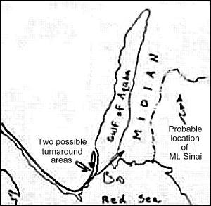
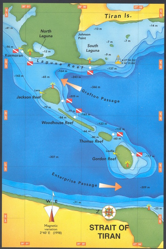
The two arrows on the left of the image above show how the Israelites may have turned and went back on themselves after being cut off by the mountains. The arrow on the right then shows the route across the gulf.
The Underwater Land Bridge Under The Gulf Of Aqaba.
To the north of the straits of Tiran the depth up through the centre of the gulf of Aqaba from ranges between 800-1800m. There is an underwater land bridge which cuts northeast from the Sinai Peninsula across the Strait of Tiran, from the airport beach going across Tiran Island. It is approximately 11.2 miles (18 km) long, at least 800 metres wide and is less than 80m below sea level, except for a 800m wide section just off the Sinai Peninsula coast which is 205m at its deepest point today (see technical note at foot of page for its depth 3500 years ago). If the Red Sea parted here it would expose a natural pathway linking the Sinai Peninsula with Arabia. Nowadays in this shallow section of the gulf, ships can only pass safely through two narrow channels which lie either side of the 4 coral reefs between the Sinai Peninsula coast and Tiran Island. The Eastern passage is called Enterprise Passage (205m deep and 800m wide), which between the Sinai peninsula's shore and the first coral reef, off of that shore, called Gordon's reef. The Western passage is called Grafton Passage (800m wide and 70m deep), which is situated between Tiran island and the reef called Jacksons reef.
Enterprise passage is part of a trough that runs the length of the gulf of Aqaba and the Red Sea. A section between the small Island now called 'Jazirat Sanafir' (the one to the right of Tiran Island on the maps), and the coast of Saudi Arabia has a maximum depth of just 10 metres!
Below is an image of British Admiralty chart #801 (our gratitude to them). Notice the 4 coral reefs (green patches) between the Sinai peninsula's coast and Tiran Island, and also the coral along the coast of Tiran Island. This coral is basically running along the land bridge, the natural pathway under the ocean the Israelites would have taken.
Here is closer view of the above (also taken from chart #801) of the same area around the reefs. It contains more details of the area around the 4 coral reefs (only 3 are pictured). You can see here that the first part of the raised area is at most 205m in depth. This is the deepest part of the land bridge, it would have been much shallower 3,500 years ago (see - technical note at the bottom of this page).
Lastly, here is the lower section of British Admiralty chart #12,
1:350,000 scale so it gives a global picture of the whole estuary. You can see the shallow coral areas (the green areas on the chart) around Tiran Island and the 4 reefs on their own. These roughly mark out the route that the sons of Israel took across to Arabia, as the coral is based around the land bridge. There is a radio mast on the Arabian side. This must be roughly where the Israelites reached the coast. If you look just to the north and south of the land bridge which runs from the airport beach via Baal Zephon across the coral reef to the Radio Mast in Arabia, the depth quickly drops from 70-200 meters to 400-500 metres.
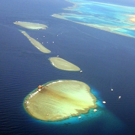
Here is a lovely photo of the straits of Tiran today. It shows the 4 coral reefs that have formed there (Gordon's reef, Thomas' reef, Woodhouse's reef and Jackson's Reef looking from left to right as shown on the maps above). The reefs have apparently grown up to 70 metres (230 ft) tall. This means their base is on the surface around 70 metres down, so their base must be situated on a raised platform, i.e. the underwater land bridge, as the rest of the Gulf of Aqaba is much much deeper. Interestingly the key ingredient in the rapid growth in coral is a food supply, i.e. a large amount of decomposing organic matter. An entire Egyptian army maybe? The coral would completely destroy the army and their horses, but there is insufficient oxygen at seventy meters to oxidize and destroy anything made of metal, such as weaponry, armour and chariot parts. So the Egyptians chariots could be further preserved by being encased in coral.
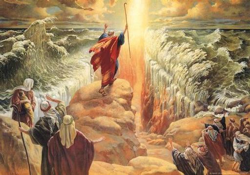
21 Moses now stretched his hand out over the sea; and drove back the sea by a strong east wind all night long and converting the sea into dry ground, and the waters were divided.
22 At length the sons of Israel went through the midst of the sea on dry land, while the waters were a barrier hmx
[often mistranslated as a wall and shown as such in Hollywood movies] to them on their right hand and on their left (Exodus 14).
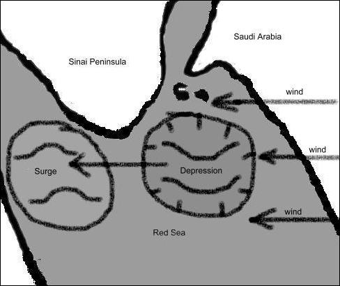
This was a very powerful wind then. Logically, the wind must have blown to the north or south of the crossing site, for otherwise it would have been impossible for the Israelites to walk into such a headwind (they were traveling Eastwards). If we assume it blew mainly to the south of the camp as in the picture below left, then wind, coming down off the coast of Arabia,
would create a depression (picture below right) in the Red Sea off that coast.
This depression would be just below the mouth of the gulf of Aqaba. The picture below right www.geocities/athens/parthenon/3021/redseaep.html
simplistically shows an equal and opposite 'surge'. This would plainly not have occurred as drawn, rather the sea would have been pushed up all the way to the opposite shore. In fact the waters in the Gulf of Suez would have risen as a result. A more accurate depiction would involve a trough on the western side of the Red Sea below the gulf of Aqaba an equivalent rise in sea level on the eastern side of the Red Sea below and in the Gulf of Suez.
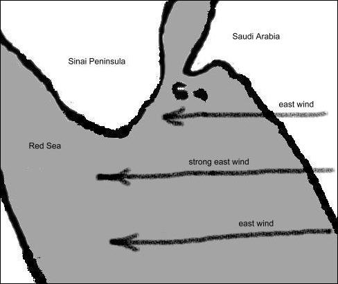
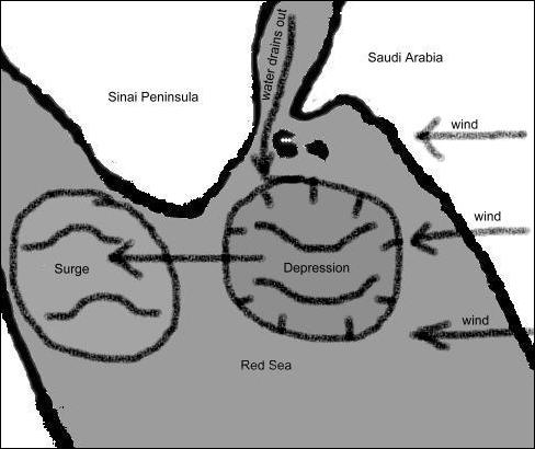
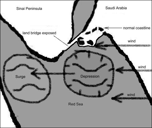
This trough created by the wind pressure, would then have drawn water out of the Gulf of Aqaba (below left). If the Red Sea tide was also going out, the effect would have been even greater. The water would have exited the gulf until the land bridge was exposed at the Strait of Tiran acting as a dam, thus temporarily turning the gulf of Aqaba into a lake (below right). The water would have bordered the temporary land bridge to the left and to the right. It would not have made a Charlton Heston, Cecil B. de Milne, wall of water. But the sea itself would have been a barrier either side the land bridge. The word used by Moses hmx
is from an Arabic root meaning 'to Guard' (Ben Davidson Analytic Hebrew and Chaldee Lexicon)..
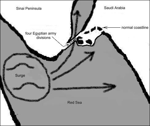
Then once the Israelites had all made it safely to the Arabian side, God would have calmed the wind, resulting in a massive surge from west to east and then northeast into the mouth of, and back into the gulf of Aqaba, wiping out Pharaoh and his army as it rushed through the strait of Tiran over the land bridge (below). The Egyptians would have been swept northwards off the land bridge down the gradient into the 500 metre then 1000 metre then 1500 metre depths of the gulf.
Interestingly, there are a number of dive clubs a Sharm al Sheik, the southernmost city on the Sinai Peninsula. Recreational diving is allowed only up to depths of 30m. To dive any deeper requires special permission from the Egyptian government. Who knows why? On July14, 2003, there was an article in Time magazine on Cambridge Professor Colin Humphreys, who, in his book - The Miracles of Exodus, postulates the theory above. He recalls seeing scientific papers on a phenomenon called 'wind setdown', in which a strong wind blowing for many hours across a large body of water causes a difference in height of up to 5m (18ft) between opposite shores. Scientists have often observed the phenomenon on Lake Erie, one of the U.S.' Great Lakes.
This theory was proven true on September8 by Hurricane Irma, the strongest Hurricane ever recorded, hitting the Bahamas and literally drying up the sea on several of its beaches?
Adrian @deejayeasya
Sea gone dry #HurricaneIrma #Bahamas @weatherchannel
2:24 AM - Sep 9, 2017 · Bahamas

Mount Sinai Is In Saudi Arabia
1 And Moses became a shepherd of the flock of Jethro, the priest of Midian, whose son-in-law he was. While he was driving the flock to the west side of the wilderness, he came at length to the mountain of the [true] God, to Horeb. (Exodus 3)
From this scripture, Moses, while residing in Midian was able to lead Jethro's flock to 'the mountain of the true God' - Mount Sinai. Now as we know, it is widely accepted today that Mount Sinai is smack bang in the middle of the 'Sinai' peninsula. But we know that Midian was in Arabia (Josephus has the Midianites based in Arabia, see - Antiquities of the Jews, book 4, Chapter 7),
so it is highly unlikely that Moses would have driven Jethro's flock hundreds of miles, around the Gulf of Aqaba, all the way into the middle of the mountains of the Sinai Peninsula. Although the Midianites were nomadic people, we know that Jethro, being the priest of Midian, would be based in Midian. So Moses would have grazed the flocks on the eastern side of the Gulf of Aqaba.
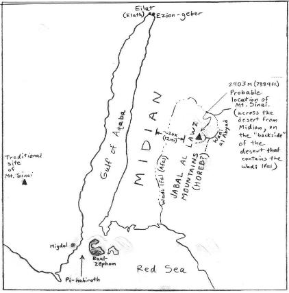
There is a mountain range in Arabia, just off the east coast of the Gulf of Aqaba, called Jabal al Lawz (picture above). This is in the exact vicinity of where Midian was thought to be. It is much more likely Moses would have came across Mount Sinai in this mountain range. This has to be where the real Mount Sinai is. Believe it or not, 'Jabal al Lawz' even means mountain of the Law!! Apparently, to this day, it is also known to locals as 'Jabal Musa', which translates as - 'Moses' Mountain'!! according to Kevin Kluetz, the author of the website from where these pictures are taken. But if you do not believe Mr Kluetz, please listen to what St. has to say on the matter.
25... Now this means Sinai, a mountain in Arabia... (Galatians 4)
So all biblical maps obviously need changing, as they all show Mount Sinai in the 'Sinai' Peninsula.....oh yes. And we had better rename the 'Sinai peninsula'!! The Red Sea Peninsular might be better?
The 3/4 way up the gulf theory
Ron Wyatt, a well known explorer/archaeologist, allegedly found what appears to be remains of the Egyptian army in 1978 further up the gulf. He along with another explorer, Jonathan Gray, have documented artifacts, some of which have confirmed as dating to the time of the Exodus. Also, recently, a man called Peter Elmer from Keynsham in Bristol, England, and his brother, who were inspired by videos of Wyatt and Gray's findings, have also claimed to have seen remains. Here is a picture taken in May 2000 by a dive team www.anchorstone.com/redsea_update02a.html.
This could be a chariot wheel, it was found at the site where Wyatt and Co. claim they saw the artifacts.

At the moment though there is not enough evidence to prove that the significance of these findings, a few pictures of chariot wheels are not sufficient to prove that the whole army is there, and neither is it sufficient to prove that the whole army entered the gulf there. But it cannot be ignored either. The site of these findings is about three quarters of the way up the Gulf of Aqaba, not at the mouth. There are some, including Wyatt, who believe that the crossing took place where these artefacts were found. However experience of bodies in the Thames river in London, which enter up river (in the tidal part) but are washed up down river to the estuary, shows us that bodies and artifacts can move around the river bed very quickly. Certainly they are in the right gulf!!
There is a land bridge, which begins at Nuweiba beach 3/4 of the way up the western coast of the gulf of Aqaba. However it is much further below sea level (approx. 765 meters) than the bridge at the Strait of Tiran,
which is presently 205 metres below sea level at its deepest. To cross at this point the Israelites would have to have taken the route to the north of the Sinia peninsular mountain range. To get to Nuweiba beach via this route you have to enter a valley, called Wadi Watir, in the mountain range,
which then opens onto the beach. This would have trapped the Israelites, as the beach is surrounded by the mountains. But it is hard to tie any of the geographical features of the bible account (Migdol, Pihahiroth, etc) to the geographical features of the area of this alternative crossing point. Also if the Israelites took the route north of the mountains then Pharaoh wouldn't have believed that he could trap them until they were too far away from him for his army to catch them up (5 days march), since they could have escaped to the North at any time. Whereas with the Southern route, Pharaoh would have believed that they were going to be trapped from the very start of the Exodus and hence started his pursuit in time to actually catch up with them.
But the marine geography of the Gulf of Aqaba is fatal for the '3/4 way up the gulf theory', because the land bridge at the mouth of the Gulf is today 550 meters higher than the 'bridge' 3/4 of the way up, so it would not have been possible to drain the gulf to reveal the lower bridge, since the higher bridge would prevent this. For once the water in the gulf had lowered to the level of the first raised land bridge at the mouth of the gulf, which today is at most 205m from the surface and 3500 years ago was probably between 25m and 100m from the surface, no further reduction in water level would have been possible.
The image below show the supposed land bridge at Nuweiba beach. The map is the top section of the British Admiralty nautical chart #12 (the bottom section is shown above), showing the north section of the Gulf of Aqaba. If you look on the west coast of the gulf, in the bottom third of the map (to the left of the letter 'A' where it says Aqaba in the water), this is where Nuweiba beach is, the other suspected crossing site. Notice how the depth at the centre of the gulf here is 765 metres, and is 263 meters and 285 meters just off of the west and east coast respectively.
You can confirm for yourself the relative depths of the two proposed land bridges from the various admiralty maps above.
However what Ron Wyatt and his team did get right (in our opinion and in the opinion of St. and in the opinion therefore of the and of God) is that he believed that Mount Sinai was in Saudi Arabia rather than being in the incorrectly named wilderness of Sinai. He and his sons went to Jabal al Lawz (the mountain of the Law) to see what they could find. Before they could find anything they were promptly arrested and spent 78 days behind bars! Apparently someone had phoned the embassy authorities in Saudi Arabia and told them that Ron and his party were spying for Israel! Perhaps they got a bit too close to the truth?
It is quite possible that the artifacts Wyatt and others have found in the Nuweiba beach area, further up the gulf, are actually remains of an Egyptian army which crossed Red Sea at the mouth of the gulf. This is because the force of the powerful surge of water which returned when the wind died, could certainly have carried Pharaoh and his army quite a way up the gulf,
and then over time, who knows where they may have been carried? But we do know that the land bridge at Baal Zephon would prevent them ever leaving the gulf. So they are in there somewhere!! The best place to search for them would appear to be just north of the strait of Tiran.
As a final technical point, the narrow trench between the beach where the sons of Israel encamped (which is now Sharm Al Sheik's airport) and Baal Zephon, is today around 800 meters wide at over 75 meters depth. But the trench has a huge volume of water, that of the whole tide of the gulf moving through it in both directions on a daily basis. This presently eats away at the depth of the trench which increases by 15 -16 mm per year www.geocities.com/athens/parthenon/3021/resea9.html
.3500 years of this gives us around 50 meters of erosion. But when the trench was smaller, it would have been eroded faster, because the waters of the gulf would have had to have passed through a smaller channel. So the erosion is less today than it was 3500 years ago. It is not hard to see that the max depth of the land bridge may only have been between 50 or 100 meters in 1513 BC rather than the 205 meters that it is today.
Even today, most people could quite easily swim to Baal Zephon, which is not much more than 1,000 meters away from the airport beach. Our thanks to Kevin Kluetz, who's website we used for a great deal of the info and images on this page - his website is www.geocities.com/athens/parthenon/3021/redsea1.html.
Randolph Gonce has made a good job of tracking the Exodus using Google Earth - see http://rgonce.blogspot.co.uk/2013/04/countdown-to-sinai.html